Site Structure
This page provides an overview of the fundamental structure of how information is organised on www.MTBtrails.info.
Venues and Trails
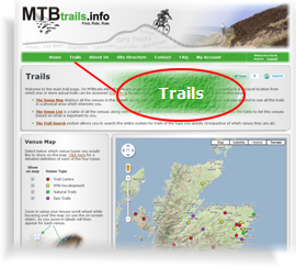 All the trails on the system can be accessed from the main ‘Trails’ page (simply click on the ‘Trails’ link in the main navigation bar). From there you can browse the trails in various ways. All the trails on the system can be accessed from the main ‘Trails’ page (simply click on the ‘Trails’ link in the main navigation bar). From there you can browse the trails in various ways.
Trails are stored in the system in groupings referred to as ‘Venues’. As a rule of thumb a venue can be thought of as a meeting point, car park, or trail-head to which a typical mountain biker might drive in order to access one or more trails. This means that particularly for ‘Natural’ and ‘Epic’ trails which tend to be out on their own, there will be many examples of venues with only a single trail (and that is perfectly ok). A venue is a meeting-point on the map, a trail has a whole sequence of points forming a route.
Venues:-
- Can not exist without at least one trail in them
- Can contain an unlimited number of trails
Trails:-
- Can only exist inside a venue
The following diagram illustrates the above along with some detail of how the various types of information can be stored in this structure.
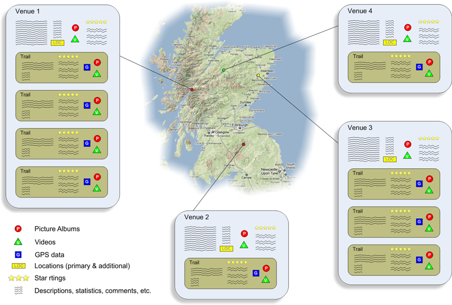
Pictures and Videos
A Picture album is a group of pictures which were uploaded together. A video is a YouTube video which has been identified to be included on the site.
As can be seen in the above structure diagram, both picture albums and videos can exist against an individual trail, or against the overall venue itself. If your pictures or video is not exclusively showing a particular trail it is best to allocate it against the venue. However, it helps the user to know what they are looking at if it is possible to allocate photos and videos against a particular trail where appropriate.
GPS Data
GPS data is pivotal to the way www.MTBtrails.info works. This data is used in order for the ‘Trail Viewer’ to provide active maps and elevation profiles, and it is also used to automatically calculate various trail statistics in a consistent manner across all the trails in the system. As a result, a trail can not exist on the system without a GPS file. This data file can come from either:-
- A GPS or mapping software file uploaded by the user.
Or,
- The ‘Point & Click’ Route Editor built into the site itself.
Either way, each trail must contain a single GPS file, and can not contain more than one (if you have more than one GPS file you want to upload, you need to create a trail for each).
Locations (Primary & Additional)
Each venue must have a ‘Primary’ location, which defines the point on the map to which people will go to in order to access the trails at that venue. However, a venue can also have a number of ‘Additional’ locations defined against it. These are intended to cater for situations where a group of trails has more than one car-park, or more than one starting point from which the trails at that venue can be accessed.
Star Ratings & User Comments
Star ratings are awarded to trails by users according to their opinion of them. This is intended to be a simplistic metric for the user’s overall like or dislike of a particular trail. The intension is that the user will enter a comment along with their rating to express any detail about why they have rated the trail as they have.
The trail’s overall rating is simply the mean average of these ratings (each individual rating along with any comments entered is also listed against each trail). It is also possible to enter a comment against a trail without providing a rating. These ‘un-rated’ comments do not affect the trail’s overall rating.
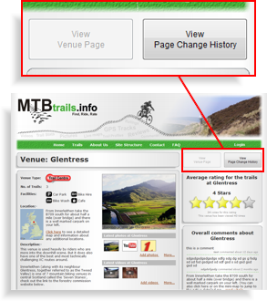
The ‘Venue Rating’ which is displayed at the top right of each venue page is calculated as the mean average of all the overall trail ratings which have been calculated at that venue. As such this ‘Venue Rating’ is really just an average of the ratings for the trails at the venue in question (i.e. it is not a separate opinion of the venue itself). Thus, users can’t award a rating for a venue as a whole. However, to give people the opportunity to express their views on the venue as a whole, you can enter comments directly against the venue.
Change History
 The ‘Venue Page’ can be thought of as the central hub of all information relating to a particular venue. The underlying concept is that the venue page itself displays the ‘current’ version of all the information, but that all changes made in the past are each recorded and listed out in the ‘Change History’ page for that venue. The ‘Venue Page’ can be thought of as the central hub of all information relating to a particular venue. The underlying concept is that the venue page itself displays the ‘current’ version of all the information, but that all changes made in the past are each recorded and listed out in the ‘Change History’ page for that venue.
Amongst the reasons for having a change history are that:-
- It provides a public record of who changed what, when, and in some cases (if the user leaves notes) why.
- It allows everyone to see how recent the various pieces of information are, and how actively a particular venue is being edited.
- It allows ‘Trusted’ users an easy way to detect vandalism, and an easy way to revert it back to a previous version if needed.
- It allows notification of any changes or additions to be emailed out to those users who have explicitly expressed an interest in that particular venue.
It is very easy to toggle back and forward between a venue page and its change history using the two large buttons at the top right of each venue page (illustrated here opposite).
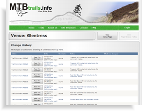 Once in the change history you will see that an entry is created in the list for absolutely any addition or change to anything which shows up in the venue page itself. Each entry in the list has a button next to it. The function of this button depends on the type of change. For example, in the case of changes to the main ‘Venue Details’ (i.e. the venue title, main description, location, facilities, etc.) this button takes you to a page which clearly highlights exactly what was changed. Once in the change history you will see that an entry is created in the list for absolutely any addition or change to anything which shows up in the venue page itself. Each entry in the list has a button next to it. The function of this button depends on the type of change. For example, in the case of changes to the main ‘Venue Details’ (i.e. the venue title, main description, location, facilities, etc.) this button takes you to a page which clearly highlights exactly what was changed.
|