Answers to 'Misc' questions
What are the user types, and what do they mean?
There are several types of user on the system. As someone makes more use of the site it is envisaged that they will progress from one type to the next in the following order:-
-
Anonymous Users
These are users who do not have an account on the site, or who have not logged-in. Anonymous users can view all the trail information in the system, but they can't edit or add anyting, and they will have none of the benefits available to those who create an account for themselves (See benefits below).
-
Standard Users
Anyone who wishes to contribute to the site, even in a very minor way, needs to create an account (the process only takes seconds). See below for a list of the benefits of creating an account.
-
Trusted Users
These are users who have proven themselves over a period of time to be genuine contributors and have therefore been given more freedom and can help with the quality control of the information on the site if they wish. See below for a list of the benefits of being a ‘Trusted’ user.
- Admin Users
These are users who have elected to give a little of their time to carry out maintenance and administrative roles on the site.
What are the benifits of having an account?
The process of creating an account is extremely quick and painless. There are no requests for unnecessary personal details. The only thing which is required is a valid email address, which once validated will allow the account to automatically and immediately go live.
These are the benefits of having a ‘Standard’ account on the site:-
- You can add to and edit most things on the site, and only your chosen username is shown in the public record of your contributions (your IP address remains hidden).
- You can create new trails and venues (though they do still need to be approved by a ‘Trusted’ user).
- You have access to post on the members discussion forum.
- You can configure notification setting so you are told when new stuff is posted about venues you are interested in (and not about those you aren’t).
- Any contributions you make will count towards you becoming a ‘Trusted’ user.
Click here to create a new account.
How do I become a ‘Trusted’ user, and what are the benefits?
In order to be automatically upgraded to be a ‘Trusted’ user you must simply have a track record of genuine contributions over a period of time.
Currently the criteria are:-
‘At least 20 contributions over a period no shorter than 1 month’
The benefits of being a ‘Trusted’ user are as follows:-
- You
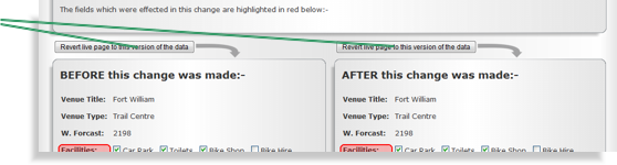 have access to the ‘Revert Changes’ buttons to undo changes made by others (to Venue details, Trail details, or to Trail Routes). have access to the ‘Revert Changes’ buttons to undo changes made by others (to Venue details, Trail details, or to Trail Routes).
This is intended as an easy way for trusted users to fix problems caused by other people making mistakes (or in some cases intentionally vandalising entries on the system).
- All adverts are removed from the site.
- You can approve trails and venues created by others to allow them to go live on the main public part of the system.
- You can have any new trails or venues you create go live on the system immediately (i.e. approve them yourself).
- You can directly edit the Route of Trails which are already live on the system.
- You can mark or un-mark specific Trails and Venues as being in need of editing (this places a notification banner on that Trail or Venue requesting help to improve the quality of the information).
- You get a nice wee ‘Trusted User’ badge against all your posts in the discussion forum :-)
What are 'Contributions'?
The total number of ‘Contributions’ you have made to-date is displayed at the top left-hand-side of your ‘My Account’ page. A contribution is anything you do which results in an entry in the change history for a venue. For example:-
- Rating or commenting on a trail.
- Uploading pictures or videos.
- Changing any of the basic details of a trail or venue.
- Adding a site link to a venue.
- Adding an additional venue location
- Creating a new venue or trail.
- Approving a trail or venue.
- Etc.
Note:-
- Posts to the member’s discussion forum are the one exception to the above, in that they don’t appear in any venue change history, but DO count as ‘contributions’.
When do I need to login and logout?
The site has been designed for convenience as a priority over super-tight security. So as you login the site will give an authentication cookie to your web browser which does not expire and is not affected by closing your browser or turning off your PC.
This means that the next time you visit the site you will immediately be recognised and not need to go through the login process. However, if you clear the cookies in your browser, use a different browser, or use a different PC, you will need to login again.
The only situation where this is likely to not be what you want is on a shared use PC (for example in an internet café). In this situation you should simply remember to ‘Logout’ once you are finished using the site (thereby removing the authentication cookie).
Which browsers work with www.MTBtrails.info?
The site is designed to work in Internet Explorer as this is still the most commonly used browser.
However, it has also been tested in Mozilla FireFox, Safari and Google Chrome. There are some minor differences in the way the site works in these browsers, but we are not aware of any significant problems.
What do the various statistics stored for each trail mean?
The fundamental concept for the statistics stored against each of the trails is that as much as possible should be automatically calculated by the site. We make no great claims as to the merits of how these calculations are carried out, but the important thing is that they provide a level playing-field on which a valid comparison can be made between trails right across the country.
Length
This is simply the total length of the trail in miles (ignoring hills). This length is automatically calculated by the system based on the route points provided (any lengths calculated by GPS devices or mapping software and embedded in the uploaded file, is ignored).
Ascent
This is not simply the vertical distance between the lowest point and the highest point on the trail. It is the accumulative total of all the vertical ascents along the trail in meters. So if there are two hills each with a vertical height of 100m, and those hills are separated by ten miles of flat land back down at the starting height (i.e. you go up to 100m and all the way back down again twice), then the ‘Ascent’ will be 200m. Flat land and decents are ignored. This figure can be though of as a way of getting a feel for how much climbing is involved in the entire trail, and is great for comparing the 'effort' needed between trails. Again this figure is automatically calculated by the system in a consistent manner for every trail, and any embedded number for this parameter in trail files which are uploaded is ignored.
Time
This is the number of hours a typical rider will take to complete the trail. Parts of hours are represented as decimal fractions of hours (e.g. 30 minutes = 0.5 hrs). This is a user configurable figure and it is intended only to be a very approximate judgement call. Just to make things even harder, this figure and the ‘fitness grade’ which is selected are interrelated, in that any trail can be incredibly demanding from a fitness perspective if it is completed in a very short time. So as a rule of thumb the times stated here should be conservative (i.e. err on the side of stating a longer time), and should assume an average ‘weekend-warrior’ level of fitness (if such a thing exists). The ‘Fitness Grade’ parameter should then be used as a very approximate indication of the level of fitness required to complete this trail taking into account its length and the amount of climbing involved (as stated below).
Tech Grade
This is an approximate guide to how difficult the trail is to ride due to obstacles, surface conditions, gradient, etc. This rating can be thought of as an indication of the level of bike skills required to ride a particular trail.
A colour coding system is commonly used to indicate trail ‘difficulty’ at trail centres and MTB developments all over the country. This is useful when comparing the trails at a given venue to each other, but it can be very inconsistent if you use it to compare trails from different venues to each other. Therefore, www.MTBtrails.info uses its own 5 step grading system from ‘Very Easy’ to ‘Very Hard’. Ultimately this is only ever going to be an ‘opinion’, but the hope is that using the following guidance, a degree of consistency will be achieved:-
- Very Easy
Typically a very smooth well maintained surface. Gentle inclines and decent only.
-
Easy
Mostly smooth well maintained surface with some bumps lumps and berms which can easily be ridden at low speed if desired.
-
Moderate
Variable surface. Small drops, jumps, rock gardens, easy north shore, etc. But all obstacles are either small and easy or have chicken runs. Some decents can be fast if you let them, but speed is always optional.
-
Hard
Surface can be challenging. Bigger drops, jumps, and rock gardens, etc. May have very challenging sections, but speed is never mandatory. Some obstacles may need to be walked round (or climbed down).
-
Very Hard
May have very large jumps, drops, and doubles etc. Gradient can be extreme. May have sections where speed is mandatory. Most obstacles do not have chicken runs.
Fitness Grade
This is intended to be a simplistic indication of the level of fitness required in order to ride a particular trail. As mentioned above, there is a level of interdependence between ‘Fitness Grade’ and the ‘Time’ which is stated. However, Fitness Grade should take into account things like the length of the trail and the amount of climbing involved.
- Very Easy
This trail is particularly short, or flat, or both. Anyone in reasonable health should have the fitness to complete this trail.
- Easy
This trail is either quite short, or does not involve much climbing. Anyone with a little experience of cycling should have the fitness to complete this trail.
-
Moderate
This is an average trail in terms of its length and the quantity of climbing involved. An averagely fit ‘Weekend-Warrior’ should have no problem completing the trail in approximately the time stated.
- Hard
This trail is either longer than most, or involves more climbing than most, or both. People who are accustomed to cycling will have the fitness for it, but for some it may take longer to complete.
- Very Hard
This trail is particularly long, or involves a particularly large amount of climbing, or both. Only people well accustomed to cycling will have the fitness for this trail, and even then some may take a long time to complete it.
Do you have guidance for writing and editing trail descriptions?
The trail description is the place to go into detail about the nature and character of a trail. The statistics and gradings stored against a trail (as defined above) are a simplistic set of categories and rough indicators. They often benefit form a bit of justification and description.
Try to keep what you say in the description as factual and objective as possible. This can be quite a gray area, but as a rule of thumb try to keep 'reviews' (i.e. things which are your own opinions) in the comments section for the trail, and things which are factual in the description of the trail (e.g. ‘This trail is amazing!!’ = an opinion, ‘The surface is mainly smooth and hard-packed’ = a fact)
The trail description is open for you to describe anything you think is useful, but here are some ideas:-
Overall trail type
Would you describe the trail as Cross-Country, Downhill, a Jump park or Freeride park, etc. Are there sections of one type, and others of another type? Can you describe where they are along the route? Or can you use ‘numbered tags’ on the route to refer to them?
Surface textures
Hard-packed, loose, kitty litter, hard-core, mud, marsh, grass, sand, concrete, forest floor mulch, roots, north-shore, rocks, solid bedrock, loose stones, etc.
Flow, gradient, feel, momentum, etc.
How steep is it (the gradient)? For the whole trail or just for particular sections? 'On the seat' steep, or 'hanging off the back of the bike' steep? Is there much pedalling needed? How well is it possible to conserve momentum between obstacles and sections? Does the trail have a good feeling of flow?
Describe obstacles and features
Rock-gardens, jumps, doubles, drops, berms, switchbacks, seesaws, balance bars, etc.
Surroundings and context
In dense forest, open forest, exposed hillside, urban environment, hills and fields, etc. Tightly weaving between trees or fast and open?
Qualify the stated technical grade
It is quite common for trails (particularly natural and epic trails) to be of one level of technical difficulty in some sections and of a completely different technical difficulty in others. In these cases the trail should have been rated at the level of the most difficult section (unless the harder section is very short and easily bypassed). The trail description is a perfect opportunity to describe any such complexities and if applicable how to avoid harder sections.
Qualify the stated fitness grade
The fitness grade is a very broad brush. You may wish to clarify why it is rated the way it is. You may also want to point out any aspects of the trail which contribute to this significantly (e.g. ‘that killer climb’, or ‘the energy sapping sandy surface’).
Blow-by-blow account of the trail
In some cases people may have the knowledge to provide a detailed account of the trail from start to finish describing the various points of interest, significant obstacles, and features along the way. The level of detail which is gone into here will obviously vary, but the more the merrier. When a Route is created it is possible to place ‘Numbered Tags’ along it. The idea of these Tags is that you can then refer to them in the trail description to indicate the position of the various sections, obstacles, changes in gradient or surface type etc.
What is the 'Sandbox' venue?
 www.MTBtrails.info is designed from the ground up to encourage everyone to edit and add to it. However, people new to the site may want to ‘play around’ a bit first, just to see how things work and to see exactly what happens when they add or change something. The sandbox is a place for people to do this. www.MTBtrails.info is designed from the ground up to encourage everyone to edit and add to it. However, people new to the site may want to ‘play around’ a bit first, just to see how things work and to see exactly what happens when they add or change something. The sandbox is a place for people to do this.
Posting these ‘experimental’ or ‘test’ edits into the system is a very natural thing to want to do to begin with. However, if carried out on the live data in the system these can become very distracting to other users and clutter up the change histories with unnecessary corrections. Asking people to use the sandbox venue instead will hopefully cut down on this problem.
The sandbox venue acts in exactly the same way as all the other venues on the system except that it does not show up on the main public venue map and none of its trails will show up in trail searches etc. So it is in effect hidden from public view (except if you want to do some experimental editing).
Click here to go to the sandbox venue.
How do trail and venue approvals work?
You must have an account in order to create a trail or a venue. The account need not necessarily be a ‘Trusted’ account, but any trails or venues created from a ‘Standard’ account need to be approved by a ‘Trusted’ user before they actually go live on the public part of the site. If a ‘Trusted’ user creates a trail or a venue they are given the option to approve their own trail thereby allowing it to go live immediately.
If you are a ‘Standard’ user:-
Any trails or venues you create will ultimately end up in the ‘Trails Awaiting Approval’ section of your ‘My Account’ page. This area only displays those trails or venues you have personally created which are waiting to be approved. Once a trail or venue is approved it will disappear from this area and appear on the main public system (while your new trail or venue is waiting to be approved, you can still edit its details by simply clicking on its ‘View/Edit’ button).
If you are a ‘Trusted’ user:-
In the ‘Trails Awaiting Approval’ section of your ‘My Account’ page you will see a list of ALL the trails and venues on the system which are waiting for approval (i.e. you will see trails created by yourself and by others). As a trusted user, you are presented with the opportunity to view, edit, or indeed approve any of them. Once a trail or venue is approved it will disappear from the ‘Awaiting Approval’ area and appear on the main public system.
Should I create a NEW Trail, or should I change the Route of an existing one?
If your route could be considered an ‘alternative’ to the existing one (i.e. the existing route is still available to use and is still valid on the ground) then you should create a NEW Trail at the same Venue as the original. That way people can look at both Trails and decide which they prefer.
If on the other hand you are correcting a mistake which was made when a Route was created, or making changes to a Route to make it match the physical reality of a trail on the ground which has changed since the Route was created on the system, then you should change the existing Route. Note: Only ‘Trused’ users can make changes to the Route of existing Trails (see below).
How do I edit the actual Route of a Trail once it is in the system?
The route a particular Trail takes is fundamental for everything else that follows. People’s ratings, comments, description edits, pictures, and videos will all assume that the Trail follows the Route as it was when they entered their contribution. Therefore, it is not possible to change the Route once it has gone live on the system unless you are a ‘Trusted’ user.
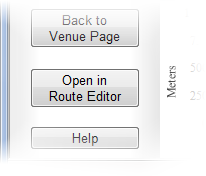 If you are a ‘Trusted’ user and you wish to edit the Route of an existing Trail simply go to the Trail in question and click on its ‘Trail Viewer’, then click on the ‘Open in Route Editor’ button on the sidebar. The ‘Route Editor’ will allow you to make all the changes you wish, and when you save the Route you will be given the option to ‘Overwrite’ the existing live Route. If you are a ‘Trusted’ user and you wish to edit the Route of an existing Trail simply go to the Trail in question and click on its ‘Trail Viewer’, then click on the ‘Open in Route Editor’ button on the sidebar. The ‘Route Editor’ will allow you to make all the changes you wish, and when you save the Route you will be given the option to ‘Overwrite’ the existing live Route.
If you are NOT a ‘Trusted’ user, you can still press this ‘Open in Route Editor’ button, but when you come to save your changes you will only be able to save a NEW Route in your ‘My Routes’ section (from which you can create a NEW Trail if you wish). This is very useful if you want to create a new Trail which is very similar to an existing one, but which has an alternative section or other slight differences.
Do you have guidance for writing and editing venue descriptions?
Venue descriptions are a place for you to describe anything which you think is useful to know about a particular venue.
Points to note
It's fine to touch on the types of trails at the venue and to talk about them in relation to each other (e.g. for comparisons), but try not to describe trails in too much detail here (detailed trail descriptions should be in the actual trail entry, not in the venue description).
Try to keep what you say in the description as factual and objective as possible. This can be quite a gray area, but as a rule of thumb try to keep 'reviews' (i.e. things which are your own opinions) in the comments section for the venue, and things which are factual in the description of the venue (e.g. ‘This place rocks!’ = an opinion, ‘Bottom car park is closed at the moment’ = a fact)
Ideas for things to include
Basically you should include anything you think is useful, but here are some ideas:-
Overview of the type of riding available
Without overlapping too much with the detailed trail descriptions, it is a good idea to give an overview of the type of riding available at this venue. What kind of people ride here? Is it mainly downhill, cross country, jump park, family friendly, or all of the above?
Background and context of the venue
If you know anything about who owns the venue, who runs it, how it came into being, how it’s funded etc. this can be a good thing to include.
Things that are unusual or worthy of note about the venue
Are there any unusual features or facilities, or anything else which is not the norm (e.g. uplift, Gondola or ski-tow)? The more normal facilities should already be listed using the provided ‘Facilities’ tick boxes, but if there’s any description or explanation required for them, this is the place to put it.
Has the venue or any of its trails been used in any competitions?
Some trails are regularly or have at some point in the past been used as part of a race or competition. Anything from being the world cup downhill course, to having been used in a minor local MTB challenge, is worth a mention if you know about it.
Current status update
It is very useful to other people if you are able to update the description of a venue to include info about its current status (e.g. car park, trail, or facility closures etc.). If you do add this kind of thing it is best to include a date so people can easily tell how recent the information is (e.g. ‘as of the End of May 2022 the top car park is closed for resurfacing, no word yet on how long this will take’).
What is GPS?
There are many online resources describing GPS in detail so we will not go into great detail here. GPS stands for Global Positioning System, and it allows anyone to use a small electronic device to receive signals from an array of American satellites in order to get a fix on their current location (normally stated in terms of Latitude and Longitude).
These devices are extremely useful for outdoor pursuits such as mountain biking due to their ability both to log a route you are following into their memory (which you can then share with others), and to guide you along a route you have obtained from others.
Click here for more on GPS.
What is a GPX file?
Unfortunately most GPS device manufacturers and mapping software writers have created their own proprietary file formats for storing GPS data, and none of them are compatible with each other. GPX is an XML based file format for storing GPS data which is not tied-in to any particular manufacturer. It is also an ‘open’ format which means its structure is in the public domain (allowing ANYONE to write software to use it).
Many of the newer devices and software allow data to be ‘imported’ and ‘exported’ to and from this format (to allow exchange of data between systems).
www.MTBtrails.info uses GPX files to store all the routes in the system, and everything which is automatically calculated or dynamically displayed on live maps uses them in order to do so.
When you upload any routes to the site they will be automatically converted into a GPX file. When you download a route from the site it will be automatically converted from the GPX file into your chosen format. If you select to download in GPX format itself you will get a copy of the raw GPX file as used by the site (i.e. without conversion).
What is the ‘My Routes’ section for?
A ‘Route’ is a record of a physical ‘way to go’ over some land. They are only one of the types of information which is stored against what is referred to on the site as a ‘Trail’. A Trail is made up of a single route, a name, description, pictures, videos, ratings etc.
The ‘My Routes’ section of your ‘My Account’ page is not public and is only visible to you when you are logged-in to your account. This area is intended as a temporary storage area to allow you to upload, edit, or create routes from scratch as much as you like before you become ready to make one of them into a ‘Trail’ on the public part of the system.
Routes are stored on the system as GPX files. These files contain only simple lists of ‘points on the map’ (latitude and longitude pairs) describing a route.
Donations
Thank you very much for considering making a donation to www.MTBtrails.info. The site is a free service and we think it is important that it remains so. However, keeping everything running does cost money and we are trying to avoid having the site cluttered up with adverts etc. So if you want to support the site and actively help keep it running please make a donation using the Paypal button below.
Thank you!
|